→Detailed Explanation
→List of Photos
AHMADABAD
It seems
that the town centre of Ahmadabad used to be at Asarwa where Mata
Bhavini's Wav currently remains. Ahmad Shah moved the capital
from Anhilwada Patan to Ahmadabad in 1411. He made a palace
complex on the elevated ground of Bhadra, fortified palace, which
faces the Sabramati River and started construction of the new
town toward the east. Buildings from this period include Mosque
of Sayyid Alam in the north Mirzapur, Jama Masjid of Ahmad Shah
at the southwest end of Bhadra, and Mosque of Hibat Khan in the
south of Bhadra.
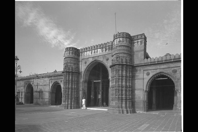
Ahmad Shah built Tin Darwaza in the east of Bhadra as the main
project of the new town development. He also constructed the main
street, Manik Chauk, that leads to the east. On the south side of
the road, Jama Masjid, his tomb and his empress's tomb were built
next to each other on the axis to the west as the centre of the
new town.
Later on, Ahmadabad saw prosperity and the town gradually became
larger. The nobility constructed new residential areas in
outskirts, which they called "Pura". Usmanpur on the
other side of the river and Rajapur to the east of town are
examples of this.
1.MOSQUE OF SAYYID ALAM (1412)
2.AHMAD SHAH'S OLD
JAMI (1414)
3.MOSQUE OF HAIBAT
KHAN (c.1420)
4.JAMA MASJID (1424)
5.MOSQUE OF QUTB
AL-DIN SHAH (1449)
6.TOMB & MOSQUE
OF AHMAD KHATTU GANJ BAKHSH (c.1450)
7.MOSQUE & TOMB
OF SAYYID UTHMAN (c.1460)
8.MOSQUE & TOMB
OF BIBI ACHUT KUKI (1469)
9.DARGAH OF SHAH
ALAM (1483)
10.MOSQUE OF MUHAFIZ
KHAN (1492)
11.WAV OF BAI HARIR (1500)
12.ADALAJ WAV (1502)
13.MOSQUE OF RANI
RUPMATI (c.1510)
14.MOSQUE AND TOMB OF
RANI SIPARI
(1514)
15.MOSQUE OF SIDI
SAYYID
(1561-1573)
16.MATA BHAVANI'S WAV (11th C.)
|
According to a
Persian inscription that is said to have been found above
mihrab at the centre of this mosque, it was built in
Rajab month in 814 AH (1412) under the Sultan Ahmad Shah
I reign by a person called Saiyid 'Alam 'Abu Bakr
Husaini. It is believed that his title was used as the
name of this mosque, despite the fact that there is a
different theory about the place where the inscription
was found. However, a theory that this mosque is the one
of the oldest mosques remaining in Ahmadabad seems to be
convincing, judging from the features found in this
building. (Matsuo Ara) →Detailed Explanation →List of Photos |
| ▲View from the east | |
 |
Among the medieval
mosques and tombs remaining in Ahmadabad, this building
belongs to those from the early period. According to a
historical inscription at the upper part of the central
mihrab, the founding of this mosque seems to be the 4th
day of Shawwal month in 817AH, which is 7 December 1414.
(Matsuo Ara) →Detailed Explanation →List of Photos |
| ▲View from the east | |
 |
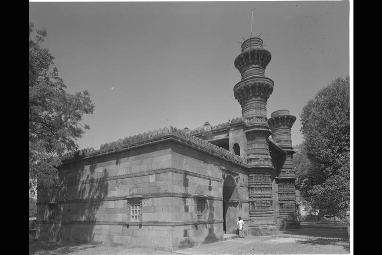
This mosque is in
the area inside the south city-gate, Jamalpur Darwaza.
There is no historical inscription suggesting its
founding date but it is believed to have been built in
the early 1420s by Haibat Khan, who was a high official
and an uncle of the second sultan Ahmad Shah I (reign
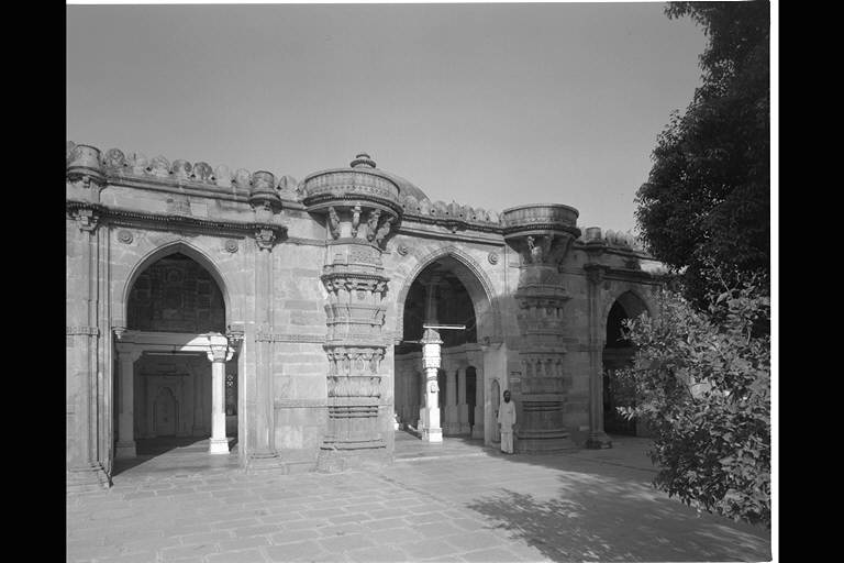
1411-42). This mosque is known by his name. (Matsuo Ara) →Detailed Explanation →Plan and Enlarged Picture |
| ▲View from the east | |
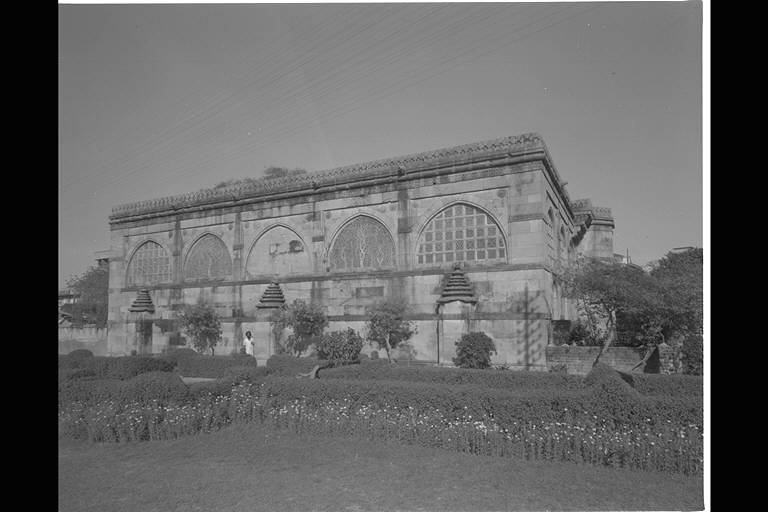
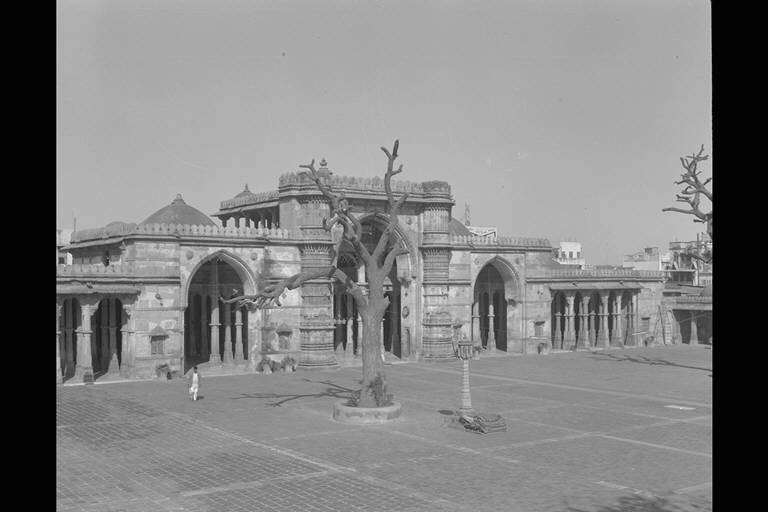 |
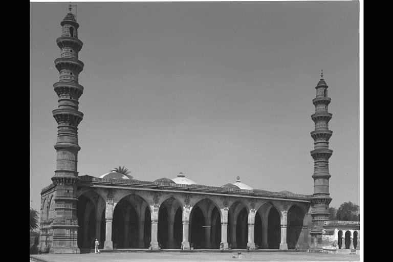
This mosque is
situated at the centre of Ahmadabad, to the south of the
main street Manik Chauk. Being Jama Masjid, this mosque
is of the most majestic construction. There are
similarities in form and structure with Mosque of Sayyid
Alam and that of Ahmad Shah. There is a theory suggesting
that it was built around 1414-15, however, an inscription
above the central mihrab seems to suggest it was build on
the 1st day of Safar month in 827 AH (January, 1424),
under the Sultan Ahmad Shah reign. Taking this into
consideration, this mosque would have been built later
than the two above mosques, in the same period as the
Mosque of Hibat Khan from the 1420s. (Matsuo Ara) →Detailed Explanation →List of Photos |
| ▲View from the east | |
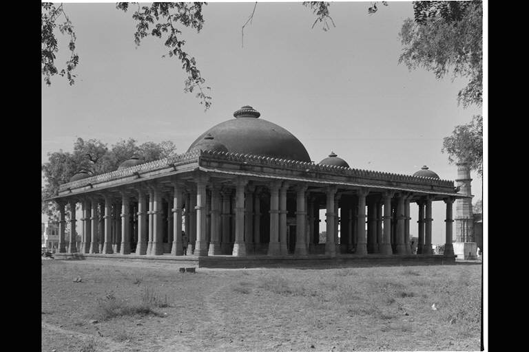
5.MOSQUE & TOMB OF
QUTB AL-DIN SHAH
 |
In this region,
this mosque is called "Pattawali Masjid" or
"Stone Mosque". It is situated at the most
flourishing part of the town where a street leading to
the south from Deli Gate branches off. Among the 5
mihrabs in the prayer room, the central mihrab is
decorated with sculpture as in other mosques. There is an
Arabic inscription above the center mihrab suggesting
that it was built by a son of "Hilal Sultani",
called "Nizam", on the 6th day of Ramazan month
in 853 AH, (October 1449) under Sulatan Muhammad Shah
reign. (Matsuo Ara) →Detailed Explanation →Enlarged Picture |
| ▲View from the east | |
6.TOMB
& MOSQUE OF AHMAD KHATTU GANJ BAKHSH
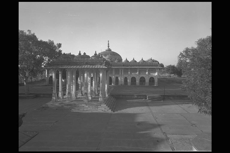 |
 |
In the Sultan
Muhammad Shah's reign, various buildings in connection
with Makhdum Shaikh Ahmad Khattu (1336-1445), a follower
of famous Sufi named Baba Ishaq Maghribi Khattu in Nagaur
at Rajhastan, were constructed 10km south-west of
Ahmadbad. (Matsuo Ara) →Detailed Explanation →List of Photos |
| ▲View from the south | ▲View from the southeast | |
7.MOSQUE
& TOMB OF SAYYID UTHMAN
 |
Sayyid Uthman was
one of the Sufi leaders under Sultan Mahmud Begarah
reign. The area on the opposite shore of the Sabramati
river, which later on came to be called as Uthmanpur, was
made the centre of his ascetic practices. The centre of
its darga consists of a mosque built in the late 15th
century and this leader's tomb. This Sufi saint died in
Jumada month in 936 AH (January 1530). (Matsuo Ara) →Detailed Explanation →List of Photos |
| ▲View from the northeast | |
8.MOSQUE
& TOMB OF BIBI ACHUT KUKI
 |
 |
Despite its small
scale, this mosque has a majestic appearance in the
Gujarati style. A historical inscription held above the
mihrab at the central prayer room suggest its founding
date is 847 AH (1469) and the name of the founder as Baha
Nek Bakht Sultan, though there is no mention of the
current name of this mosque Bib Achut Kuki. Dr. Rajan
assumes that this woman may have been an important figure
living in a harem. This is one of the important buildings
that was constructed under Sultan Mahmud Begarah. (Matsuo
Ara) →Detailed Explanation →List of Photos |
| ▲Masjid | ▲Tomb | |
 |
 |
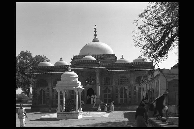
Muhammad Shah Alam,
a son of Burhan al-Din who was the founder of Bukhariya
Saiyid, and his group had a great religious influence in
the Gujarati region and were respected by the ruling
class of the Ahmad Shahi dynasty. His dargah consisting
of the tomb of Shah Alam, a mosque, tombs and Jama'at
Khana (Assembly Hall) is the most famous religious centre
among those still venerated by religious Muslims in
Gujarat. (Matsuo Ara) →Detailed Explanation →List of Photos |
| ▲Tomb of Shah Alam | ▲Masjid | |
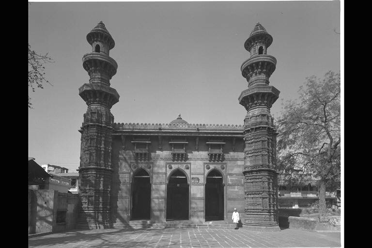 |
Muhafiz Khan's
original name was Jamal al-Din Silahdar and he was one of
the officials of the 7th sultan Muhmud Begarah. He later
became one of the wazirs. This mosque referred to with
his name is said to have been built by him. It is
situated in the south of Qutb Shah's Mosque facing a road
leading to the south from the north gate or Delhi
Darwaza. Compared to the other mosques in Ahmadabad, it
is smaller, however, it is a mosque with a remarkable
character, having oriels on the upper part and three high
arches down below on the facade in the east, and minars
at either side. (Matsuo Ara) →Detailed Explanation →List of Photos |
| ▲View from the east | |
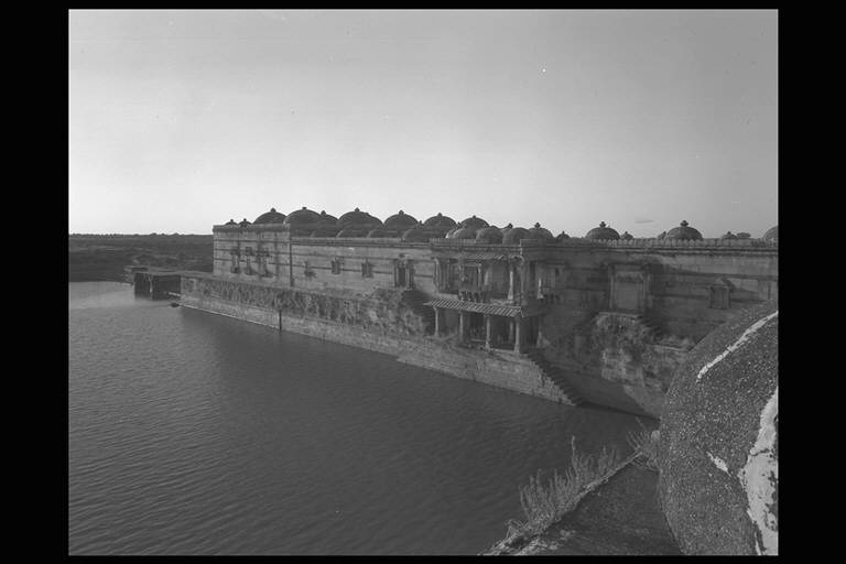
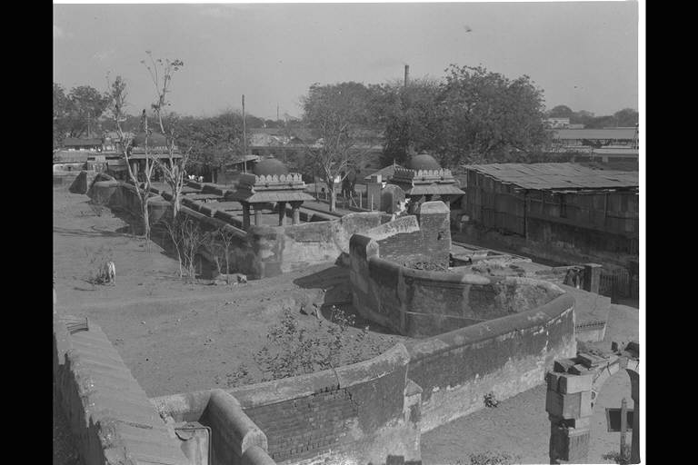 |
These remains are
near the wav of Mata Bhavani in the northeast outskirts
of Ahmadabad. There remain wav or baoli (step well), a
mosque and a tomb. Because of its distinctive weather and
social conditions, this region rulers built a number of
reservoirs and baolis. This step well is known to have
been built in 906 AH (1500) under the 7th sultan Mahmud
Begarah, through an inscription remaining in the well and
a neighbouring mosque. (Matsuo Ara) →Detailed Explanation →List of Photos |
|
| ▲View from the southeast | ||
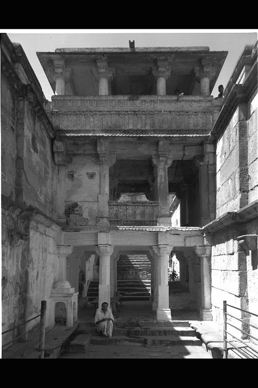
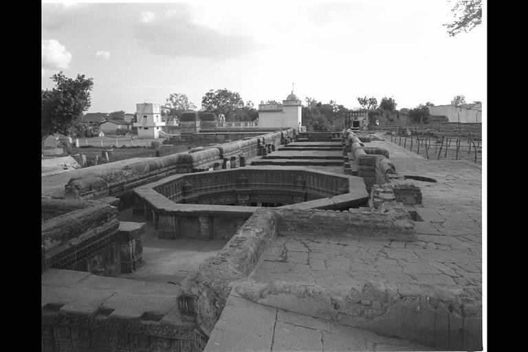 |
This well is
situated in the north outskirts of Adalaj, 20km from
Ahmadabad. It is a step well, built around the same
period as the well in Bai Harir. However, it is the
biggest well existing in Ahmadabad and it has the most
elaborate structure. The entrance is on the south side
and the stairs continue to the north. At the northernmost
part, an octogonal and circular shafts for storing water
have been built. At the entrance hall in the south, the
stairs to the ground also connect to the west and east,
shaping a cross. This point is different from the other
wells. Dr.Burgess assumes that this entrance hall may
have been covered by a dome. A Sanskrit inscription at the entrance hall suggests that it was built by Princess Rujuha of Vilasimha in 1502 under Mahmud reign. To reinforce this, there are Hindu gods statues and Hindu motifs seen in details of the building. (Naoko Fukami) →List of Photos |
| ▲View from the northwest | |
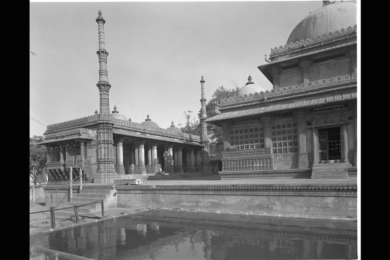
13.MOSQUE & TOMB OF
RANI RUPMATI
 |
The central part of
the east entrance has a similar structure to the Mosques
of Bai Harir, having a high arch-shaped central entrance
and heavy minars with rich decorations on either side.
The central hall with clear storey in well hole style has
a dome supported by 12 long slender pillars. The ceiling
inside the dome is decorated by Hindu style patterns. On
both sides of the central part of the high dome, there is
a room with a low dome, which is of a style following
Mosque of Bibi Achut Kuki. However, this mosque has
elaborate oriels on both sides of the entrance arch that
have similar construction and sculptured patterns to
those seen in heathen buildings. (Matsuo Ara) →Detailed Explanation →Enlarged Picture |
| ▲View from the east | |
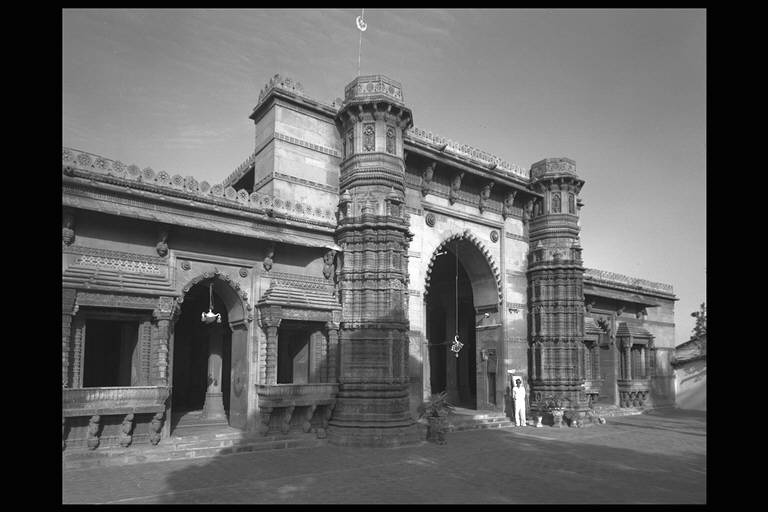
14.MOSQUE
AND TOMB OF RANI SIPARI
 |
These are mosque
and tomb built inside the Astodiya gate remaining at the
southeast side of the Ahmadabad. By a historical
inscription held at the upper part of the central mihrab
in the mosque, it is understood that these buildings were
built by Rani Sipari, the mother of Abu Bakr Khan, who
was the child of Sultan Mahmud Begarah, in 920 AH (1514)
under the reign of sultan Muzaftar the 2nd. The mosque
and the tomb are built on the same basement considerably
higher than the ground level, being separate from each
other but on the same axis. (Matsuo Ara) →Detailed Explanation →Plan and Enlarged Picture |
| ▲View from the southeast | |
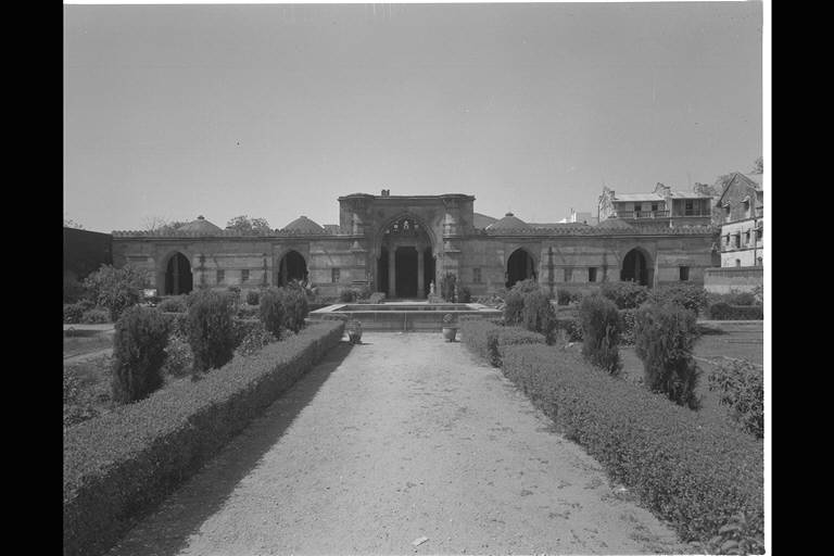
 |
This mosque is
widely known overseas because of its elaborate
brattishing decoration inside the arches at the upper
part of the north and south walls. It is a mosque built
in the Bhadra fort remaining at the westernmost part of
the walled town of Ahmadabad. It was built under the 17th
sultan Muzafar the 3rd (1561-73) by his senior official
called Shaikh Said. (Matsuo Ara) →Detailed Explanation →List of Photos |
| ▲View from the west | |
 |
This is a step well
in Asarwar situated to the northwest of WAV OF BAI HARIR.
This well is of long with the ends projecting east and
west. It has an entrance on the east side. The staircase
goes down to the east and at the east end, there is a
circular shaft. Water in the circular shaft was brought
up by cows and is said to have been used for irrigation.
It was built in the form of stairs because the water
level changes depending on seasons, in rainy season the
level went up and dry season it went down. The name
"Mata Bhavani" seems to have come from the
small shrine at the circular shaft in the west. Burgess
suggests that this wav may date back to the 11th century,
before Islamic power spread to Gjarat, although there is
no document to suggest it. He also mentions that the
Bhavani's shrine may be that of later years. (Matsuo Ara)
→List of Photos |
| ▲View from the west | |
